
It was late one evening in 2017 when somewhere in the minds of Dr Michael Fradley and his colleague Dr Andrea Zerbini a light flickered on.
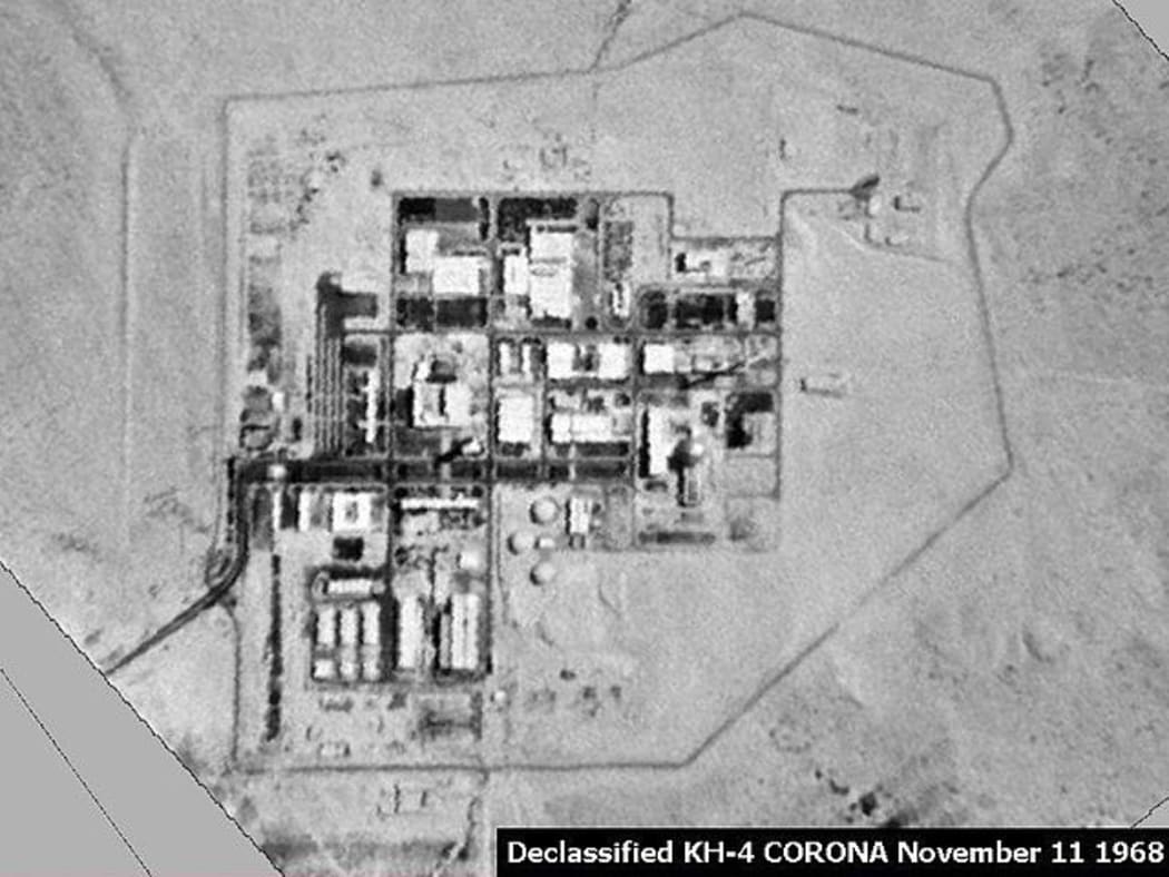
The Shimon Peres Negev Nuclear Research Centre. Photo: Wikimedia Commons: American Reconnaissance Satellite KH-4 CORONA
The two Oxford University archaeologists often found they worked better after hours, once the office had emptied and with no phone calls or emails to distract them.
Both specialists in the Middle East, the pair were two years into a project involving satellite imagery of Israel and the West Bank when they noticed something odd.
"From the start, we knew that there was a problem," Fradley said.
They were trying to access photos taken over Israel but noticed they were all blurry, and not high enough quality to make out any of the details on the ground they were looking for.
The blurry satellite imagery of Israel
They didn't know it then, but Fradley and Zerbini had run into an obscure US regulation known as the Kyl-Bingaman Amendment, which compelled the US government to blur satellite imagery exclusively over Israel and the Palestinian Territories.
During the Cold War, the United States' satellite program was as much a political instrument as it was a practical one. And at the time, lobbying of the US Congress by Israel, which argues allowing open access to satellite pictures endangers its national security, led to the passing of the little-known amendment at the end of the millennium.
With many of the world's largest commercially available satellite systems having long been owned by American companies, this has meant for decades satellite imagery over Israel on websites like Google Earth has been blurred out.
To the minds of the two researchers, there didn't seem to be a whole lot of information about the problem on the internet, and the situation presented an interesting challenge.
So, over many evenings in 2017, the pair got to work as they tried to find a workaround to accessing the detailed satellite imagery needed for their archaeological research.
Working from their modest office on campus, they trawled what felt like every corner of the web, skimming through reams of declassified reports and endless newspaper clippings.
Suddenly Fradley and Zerbini found themselves in territory that was at once familiar and unfamiliar - the work gave them the same thrill of the hunt for new knowledge.
But it also gave them a feeling they were part of something subversive. They had become quasi-internet sleuths looking for answers on a subject that was very different to their day jobs.
"We were archaeologists," Fradley laughed.
"We didn't really know anything about space law."
Finally, after two weeks of head-scratching, the pair had a breakthrough.
A French loophole to the rescue
The solution at first seemed so obvious that Dr Fradley's immediate thought was that they had made a mistake.
The pair had discovered there were other companies producing satellite imagery, at a cost. That included Airbus, a French aerospace company, which was among the first non-American companies to produce high-resolution satellite imagery of Israel and the Palestinian Territories, unbounded by the Kyl-Bingaman Amendment.
Having obtained clearer satellite pictures, Fradley and Zerbini set about publishing their findings, and wrote to the National Oceanic and Atmospheric Administration in the US, the agency that regulates satellite systems, to alert them to their discovery.
Under the Kyl-Bingaman Amendment, Israeli satellite imagery must specifically be "no more detailed or precise than satellite imagery of Israel that is available from commercial sources".
In July 2020, after some back and forth, the Kyl-Bingaman Amendment was quietly updated to remove its exception for Israel.
In response, the Israeli Defence Ministry's head of space programs told an Israeli radio station that "we would always prefer to be photographed at the lowest resolution possible".
"It's always preferable to be seen blurred, rather than precisely," Amnon Harari said in July.
The rule change opened up brand new opportunities for scientific and environmental research that had previously been impossible, but it also led to some unexpected discoveries.
The mystery of the nuclear facility
In Dimona, a small city nestled in the Negev desert of southern Israel, is a nuclear plant first built in secret in the 1950s.
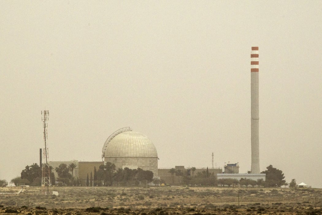
A picture taken on 8 March 2014 shows a partial view of the Dimona nuclear power plant in the southern Israeli Negev desert. Photo: AFP PHOTO / JACK GUEZ
Israel maintains a policy of what is known as "nuclear ambiguity", meaning it neither confirms nor denies the existence of a nuclear program, and it is not a signatory of the Nuclear non-Proliferation Treaty.
The airspace above the facility is closed to passing aircraft, but if a plane were to fly over its passengers would see below them a collection of squat buildings lining a grid of roads, all surrounded by sand.
For decades, that layout has barely changed.
But in February an international group of nuclear experts noticed "significant new construction" from analysis of commercially available satellite imagery.
That imagery was made recently available by the relaxing of the Kyl-Bingaman Amendment.
Shortly afterwards, high-resolution photos of the Dimona facility produced by American company Planet Labs - only available since the relaxing of the Kyl-Bingaman Amendment - was obtained by the Associated Press, revealing a new dig about the size of a soccer pitch.
"[What] the Israeli government is doing at this secret nuclear weapons plant is something for the Israeli government to come clean about," Daryl Kimball of the US-based Arms Control Association told the Associated Press at the time.
Andrea Zerbini never saw the fruits of his labour
Today, Fradley is still an archaeologist at Oxford University and looks back on the satellite imagery saga he helped shape with fondness.
"It was a really happy moment," he said, recalling the day the US government told him the rules were changing.
"But it was tinged with real sadness."
In 2018, his research partner and colleague Andrea Zerbini died after a battle with a rare form of liver cancer.
"He was the only other person who really kind of understood the nuances and how much we put into it," Fradley said.
In an obituary for Zerbini, Fradley paid tribute to his friend and colleague.
"It is our work in early 2017 investigating an obscure piece of US [satellite] legislation that really sticks in my mind when I think of our time working together," he wrote.
"We were immensely proud of the work that we had done."
- ABC

